My reminiscences, thoughts, and travel experiences
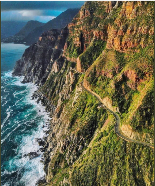
Chapman’s Peak Drive, Cape Town, South Africa. Scenic Splendor, Route History, and Upgrades
I was born in Cape Town. There are many sights that are the pride and joy of the Mother City, and its environs. Linda and I drove the scenic Chapman’s Peak Drive today. I planned to do research but found this perfect website below. I copied and pasted its content below. The editing was to Americanize the spelling and insert comments to clarify terms from Afrikaans and to update currency to today’s figures. The video is 15 minutes in length.
Near the halfway mark, you will see the major engineering work that added safety to the road. Along the drive observe the fencing used to catch rocks that may fall from above. Linda and I have driven portions of the scenic Pacific Coast Highway in California, yet the much shorter Chapman’s Peak Drive has a beauty of its own. As you read in the detail below, it is fascinating to understand the number of challenges that needed addressing over the years prior
The website linked provides traveler information such as current weather and road conditions, toll rates, status if the drive is open, etc. Its historical content is published below with minor editing.
Chapman’s Peak is named after John Chapman, the Captain’s mate of an English ship, the Consent. The peak, which looms overhead, was not named after a governor or brave mountaineer, but a lowly ship’s pilot. In 1607 the skipper of the British ship Contest found his vessel becalmed in what is now Hout Bay (wood bay) and sent his pilot, John Chapman, to row ashore in the hope of finding provisions. The pilot later recorded the bay as Chapman’s Chaunce (chance) and the name stuck, becoming official on all East India charts.
In the early 1920’s Sir Nicolas Fredrick de Waal, the first administrator of the Cape Province, ordered the construction of a high-level road linking Cape Town with the Southern Suburbs. The roadway (De Waal Drive) was extremely well received. Enthused with the success he called for another road linking Hout Bay to Noordhoek (north corner). Two routes were under consideration in 1910. The route over the low neck between the Chapman’s and Noordhoek Peaks was second to the more spectacular route along the vertical sea cliffs.
In 1914 preliminary surveys on the road got underway. Surveying the route was a scary business. The cliffs and ravines were steep, rotten and unstable, and at times the surveying party was on all fours as they investigated the perpendicular terrain. The route over the neck appeared to be no better, and the project was expensive and a mission impossible. De Waal, however, would not take no for an answer, and eventually, he ordered the ‘go ahead’ for along the cliffs which appeared, at the time to be the better option.
The road was cleverly planned with the road surface based on the solid and conveniently located 630-million-year-old Cape Granite contour, while the many roadside cuttings would be carved out of the more workable Malmesbury series sediments.
In 1915, with the use of convict labor supplied by the newly formed Union Government, construction began from the Hout Bay end, and in the following year, work began from Noordhoek. The first portion of the road to the Lookout was opened in 1919.
This spectacular roadway took seven years to complete, at a cost of ₤20 000. (₤100 million in today’s currency, or US$130 million). The Hout Bay – Noordhoek Road ‘hewn out of the stone face of Sheer Mountain’ was opened to traffic on Saturday 6 May 1922 by the Governor of the Union of South Africa, His Royal Highness Prince Arthur of Connaught.
In 1962 a section of the road was widened, and in 1977 a portion of the road was washed away, and subsequently, the road was closed on 14 May, after a large section was washed away and the damaged section was replaced by a bridge at a cost of R150 000 (R5.5 million in today’s money or US$ 400,000).
Road Closure in 2000
In 1994, Noel Graham was injured and partially paralyzed in a landslide incident on Chapman’s Peak Drive, which resulted in a court case against the Cape Metropolitan Council was the road management agent at the time of the incident. In February 1999, a High Court judgment was given against CMC for negligence in the management of the road. The matter was appealed by the CMC, but the Supreme Court dismissed the appeal in November 2000, thus reaffirming the Cape High Court’s decision, and CMC was ordered to pay all claims and costs.
Amidst increasing concern for public safety and legal liability, the South Peninsula Municipality (SPM) – the new road management agent appointed in 1997, established a sub-committee of officials from the local, metropolitan, and provincial authorities to guide the management of Chapman’s Peak Drive, who instigated high visibility rockfall warning signs to be erected on Chapman’s Peak Drive during 1999. The sub-committee also adopted a specific Chapman’s Peak Drive closure policy which inter alia stipulated that the road had to be closed to traffic in rainy weather (exceptionally light drizzle excluded) and remain closed for several hours after cessation of any rainfall and until deemed safe by SPM’s road management staff. This closure policy/procedure was implemented by SPM’s road management staff with lockable booms put in place to prevent unauthorized entry.
On 29 December 1999 however, a falling rock caused the unfortunate death of a Noordhoek resident. In early January 2000, Ms. Lara Callige was killed, and a passenger in the same car was seriously injured in a rockfall incident on Chapman’s Peak Drive in clear weather conditions when the rockfall risk on the road was not considered to be high. This was of sincere concern to the local and provincial authorities alike and emergency meetings to discuss the closure of Chapman’s Peak Drive were held between the relevant political bodies. Before a decision could be taken on the matter, and still in January 2000, the worst mountain fires in many decades raged in the Cape Peninsula, including in the mountains above Chapman’s Peak Drive, causing numerous rock falls onto the road and effectively rendering the road impassable.
Because of these incidents, Chapman’s Peak Drive was officially closed to traffic indefinitely by the Provincial Minister of Transport in January 2000.
Development 2000 – 2003
Based on the recommendations of geotechnical specialists, the Provincial Administration’s Transport Branch made available funding for “rock barring” (a term used for removing loose or dangerous rocks) of the mountain slopes above the road to make them safer. Contracts for this work were awarded in March 2000 by the SPM.
It soon became apparent that the rock barring process deemed would take longer than originally anticipated and cost commensurately more. The work was thus stopped in May 2000 and an integrated environmental management process (IEM) was put in place with the goal of producing an agreed management plan for Chapman’s Peak Drive by mid-2001. The IEM process brief required management to include:
the improvements deemed necessary to make the road safe for users,
a strategy for managing/operating the road,
recommendations on funding sources for capital improvements as well as the continuing operational needs.
At the end of April 2001, the IEM process included:
A review of the initial “rock barring” work concluded that some rock barring may be necessary for the final upgrading process, but the “clean sweep” approach could not be condoned and the selective rock barring also would have to be accompanied by various engineered rockfall protective measures in order to make the road safe for users.
A comprehensive stakeholder workshop in September 2000, identified and agreed to various improvements and protective measures, which needed to be implemented on Chapman’s Peak Drive with the overriding and urgent requirement to re-open the road to traffic as soon as possible being supported by all participants.
A detailed site survey of the road itself and the mountainside above and below the road to facilitate a concept design proposal (areas covered by rock and the time had to be omitted).
Completion of various concept design proposals incorporating some or all the following elements: rock barring, catch fences, rock gallery protection, concrete roof protection, existing structure repair, road surface, and layer work repair, slope stabilization work above and below the road, etc.
Public meetings were held in late November 2000 to present the status of the project to the public in the Hout Bay and Noordhoek Valley areas and obtain relevant feedback from interested and affected parties, and further meetings in March 2001 presented the progress on the project.
The IEM process was guided by a project management team consisting of officials from the Provincial Administration, Western Cape, and officials from the City of Cape Town’s South Peninsula and CMC administrations.
Public-Private Partnership (PPP)
The legal road authority for Chapman’s Peak Drive is the Provincial Administration Western Cape (PAWC) realized early on in 2000 those financial limitations would be the single biggest obstacle to the safe re-opening of Chapman’s Peak Drive to traffic. To solve these financial problems the plan was to implement a public-private partnership and proclaim the route a Toll Road under the Western Cape Provincial Toll Road Act. The feasibility study concluded that most of the costs attached to the Chapman’s Peak Drive reopening and operation could be obtained through tolling the road and that a public-private partnership with a concessionaire demonstrated value for money in terms of the risks transferred to the private sector.
The Chapman’s Peak Engineering Group Joint Venture was awarded the tender after being shortlisted and the project was overseen by Entilini concessions – the special-purpose company established by the consortium of Concor Holdings, Haw & Inglis, and Marib Holdings.
The Joint Venture included Vela VKE Consulting Engineers, Meli & Du Plessis Geotechnical Engineers, Stewart Scott International, Zietsman Lloyd Hemsted and assisted by Megan Anderson Landscape Architect (environmentalist); OvP& Associates (landscape architect); Dr. Ross Party-Davies (geotechnical specialist) and Prof Rolf Kratz (structural design specialist).
Due to its sensitive location within the Table Mountain National Park, an integrated environmental approach to the rehabilitation and upgrading of Chapman’s Peak Drive was required. See details on the engineering page of work that was undertaken to ensure that rockfall protection measures were put in place along with an advanced traffic management system.
2003 – Present
After intensive design and reconstruction, Chapman’s Peak Drive was re-opened to traffic as a toll road on 20 December 2003. The opening was a welcome return for the drive as an “international tourist destination” complementing other tourist destinations in the Western Cape. Local businesses also welcomed the re-opening.
The new rockfall measures were, however, put to the test, and during July and August of 2004, three rainfall incidents occurred of extremely high intensity. A total of 396mm was recorded in the 2 months, compared to the mean annual precipitation for the area of 740mm! Shortly thereafter several debris slides and rockfall incidents occurred, resulting in damage to the catch fences, and Chapman’s Peak Drive was closed for 55 days to clear the debris and replace the 4 catch fences.
The much-loved road was back in the news when Chapman’s Peak Drive was once again declared unsafe for road users in June 2008 and the drive was closed for major upgrades and repairs. The construction work took over a year and was eventually re-opened on the 9th of October 2009. Chapman’s Peak Drive has remained open since then, albeit with temporary closures for routine maintenance and during dangerous weather conditions.
It is one of the most beautiful scenic drives in the world and was an engineering feat initially planned as the Hout Bay-Noordhoek Road. The peaks above the bay were named after John CHAPMAN, the first English name given to a geographical feature in the Cape. In 1607 Chapman was the first mate on an English ship, the Consent, that was unable to sail due to a lack of wind in what is now Hout Bay. He was sent ashore to find fresh water and provisions. The ship’s captain recorded the bay as Chapman’s Chaunce meaning chance).
Sir Nicolaas Frederic DE WAAL (1853–1932), Administrator of the Cape from 31 May 1910 to December 1925, ordered the construction of a road linking Cape Town and the southern suburbs (De Waal Drive), and a road linking Hout Bay and Noordhoek. Two routes were considered – one was over the neck between Chapman’s Peak and Noordhoek Peak, and the other was along the cliffs beside the sea. In 1914, the cliff road seemed an impossible task and too expensive. Looking at the route over the neck, the surveyors reported there were very steep, unstable slopes; the ground would not support a road, and mudslides and rockfalls would be a hazard. The vertical cliffs on Chapman’s Peak were deemed a better choice.
Charl MARAIS was the surveyor in charge during the construction. He was born at the Cape in 1862. He worked on the rail link between the Transvaal and Mozambique, having been part of the expedition to find the route of the Komati-Selati railway. During the expedition he saw how game was being slaughtered in the Selati district and informed President KRUGER, which laid the seed for a game reserve. Marais considered the work around the mountain his greatest achievement. It was dangerous work – he once fell to the granite boulders below and was saved by a protea bush that did not come loose when he grabbed it.
Construction started in 1915, with the use of convict labour, from the Hout Bay end. In 1916, work began from the Noordhoek end. Construction involved engineering expertise and mountaineering skills. Workers used picks, shovels, and controlled blasting with explosives to carve the route into the cliff face. Equipment was hauled up the steep cliffs by rope and men had to be roped to each other as they clung to the rock. The first portion of the road to the Lookout was opened in 1919. The project was completed in 1922 at a cost of £20,000. It was opened to traffic on 06 May 1922 by the Governor of the Union of South Africa, His Royal Highness Prince Arthur of Connaught.
In early October 1925, an accident happened on the Kommetjie side of the Peak. A charabanc, with 24 men from the southern suburbs, was proceeding up a slight incline when it suddenly swerved and toppled sideways over the embankment. One occupant, O’CONNELL of Wynberg, was seriously injured and died shortly afterwards. Thirteen others were taken to Simon’s Town hospital with serious injuries. Six escaped with no injuries. Two Navy men from Simon’s Town jumped out before the vehicle went over, one of them was KNIGHT of HMS Lowestoft. A passing motorist drove him to Sir Drummond CHAPLIN’s house nearby to summon medical help. Sir Drummond drove to the scene to assist with the rescue. The driver, C. COWNEY, died the next day. The vehicle was one of the Tramway Company’s large yellow charabancs. An inquest returned a verdict of accidental death.
In November 1933, a motor car was found in the sea below the Chapman’s Peak road in an inaccessible spot. Police were dispatched from Hout Bay to find out if there were any victims. A Cape Town number plate was found halfway down a cliff, and at the back of the plate there were Johannesburg numbers. The police later found that the car had been stolen from Hout Bay the night before and belonged to an Indian merchant. When last seen on the road, there were three men in it.
In 1937, Roman VAN WILDEMAN, a farm manager of Klipheuwel, was found guilty of fraud. He pushed his Morris motor car over a cliff into the sea at Chapman’s Peak and then submitted an insurance claim for theft of his car. He was sentenced to four months’ imprisonment with hard labour, suspended for two years on condition of good behaviour. Van Wildeman said he needed the money to send his mother overseas as she was very ill.
In mid-July 1950, the road was closed for a week due to rock falls after heavy rainfall.
In February 1953, a car stolen in Woodstock was found 40 feet below Chapman’s Peak.
In June 1953, six Royal Navy men from Slangkop radio station in Kommetjie climbed Chapman’s Peak without equipment and planted a Royal Naval White Ensign and a Battle Ensign in honour of the coronation of Queen Elizabeth. They were Leading Telegraphists R. THROUGHTON, M. WARR and A. BARRS, and Telegraphists P. COOK, C. JOHNSTONE and A. MARTIN. They climbed through a bank of cloud and the sun was out when they reached the summit. An icy wind was blowing and the ground was wet and slippery. When they returned to the radio station, they celebrated with orange squash, and later that day the canteen was opened for a stronger toast.
In December 1953, three policemen climbed down precipitous rocks near the middle of Chapman’s Peak, where a small car had gone over the edge. There were no people in the car that belonged to Constable J. BOSMAN of Wynberg. It was stolen in Muizenberg the previous night. This was the fifth time in the past five years that vehicles had gone over the edge, all within a mile of each other.
In December 1955, a motor car plunged into the sea from Chapman’s Peak, while the driver, Mr E.W. GROENEWALD and his companion were taking photographs a short distance away. The car had been parked on the side of the road.
In 1962 a section of the road was widened.
In 1976, a troop of baboons stoned a car laden with eggs on Chapman’s Peak and smashed the windscreen. The driver, Mr Vivian MIKADA, was taking eggs from a poultry farm at Hout Bay. He was not hurt and none of the eggs were broken. He blamed visitors from the Transvaal who feed the baboons when visiting the Cape.
In November 1976, a Triumph Spitfire sports car crashed through a stone barrier and plunged over a sheer cliff near the top of Chapman’s Peak. The driver was not found after a long search by police and the Mountain Club of South Africa. The car belonged to Mr D.G. FOURIE of Gardens who had reported it stolen.
In 1977 a portion of road was washed away, and the road was closed on 14 May. The damaged section was replaced by a bridge at a cost of R150 000.
In November 1979, a gang of eight baboons attacked a Fidelity Guards van, leaving it with a cracked windscreen and badly dented bodywork. The armoured car driver, Junior RADYN and his colleague Colin LAWSON were driving towards Noordhoek when the gang pelleted the van with rocks.
In December 1982, Tiene VAN STADEN of Brakpan and his son were attacked by a baboon at Chapman’s Peak. The family was holidaying in Cape Town and went for a drive. They saw the baboon sitting on a wall. Van Staden got out of the car and his son Martin (3) followed him before he could stop him. A smaller baboon grabbed Martin and the bigger one jumped on him. The father grabbed the child and threw him into the car. He then drew his revolver and fired at the baboon, missing him.
In December 1983, an 11-year-old girl was bitten by a baboon on Chapman’s Peak drive, soon after it had been fed by people standing near a sign warning them not to feed the animals. Her father, Hugh DENNY, said the family were on holiday and had stopped and got out of the car to see the views. They saw a group of four people feeding seven baboons nearby. One of the baboons rushed the family and bit Robin on her arm.
In 1994, Noel GRAHAM was injured and partly paralysed in a landslide incident on Chapman’s Peak Drive, which resulted in a court case. High visibility rockfall warning signs were erected in 1999. A closure policy was put in place, which inter alia stipulated that the road be closed to traffic in rainy weather and remain closed for a number of hours after cessation of any rainfall and until deemed safe. Lockable booms were erected to prevent unauthorised entry.
On 29 December 1999, a falling rock caused the death of a Noordhoek resident. In early January 2000, Lara CALLIGE was killed, and a passenger in the car seriously injured in a rockfall incident in good weather conditions. Later that same month, fires raged in the mountains above Chapman’s Peak Drive, causing numerous rockfalls. The road was closed to traffic indefinitely. After intensive design and reconstruction Chapman’s Peak Drive was re-opened to traffic as a toll road on 20 December 2003.
During July-August 2004, heavy rainfalls led to several debris slides and rockfall incidents. Chapman’s Peak Drive was closed for 55 days to clear the debris and replace four catch fences. In June 2008, the road was closed for major upgrades and repairs. It re-opened on 09 October 2009. The winding road has 114 curves and remains open, with temporary closures for routine maintenance and during dangerous weather conditions. It is affectionately known by South Africa’s as Chappies.
Copyright 2026 South African Researcher – Family History & Heritage. Please don’t steal my content. These posts are from my personal collection of 40+ years that I’ve researched and post as original content here (no AI used). If you’d like to share my work, please use the post’s share option.